Article · 4 March 2022
Reclaimed water against wildfires in the wildland-urban interface: the UIA-GUARDIAN project in Riba-roja de Túria and Paterna
How GUARDIAN uses advanced-treated reclaimed water for green firebreaks and prescribed irrigation to protect the wildland-urban interface in Valencia.
Javier Anguiano Aranzubia
Hidraqua
Jose Morales
Riba-roja de Túria Town Council
Ferrán Dalmau Rovira
Medi XXI
Lydia Puchol Rodríguez
Medi XXI
Francesc Hernández Sancho
University of Valencia
Carlos Echevarria Diez-Canedo
Cetaqua
ABSTRACT
Wildfires in the so-called wildland-urban interface (WUI) have become a growing risk for these areas, as recently shown, among others, by the events with a high number of victims in 2018 in Greece and California, and in 2017 in Portugal and Spain (Galicia).
The innovative technologies and strategies successfully applied in recent years, based on increasing the availability of structural water in green firebreaks and on fire prevention/suppression irrigation, face the problem of the availability of the necessary water resources. This barrier is particularly significant in areas where the water stress associated with climate change simultaneously increases fire risk.
The GUARDIAN project, carried out in the Valencian municipalities of Riba-roja and Paterna and supported by the European Union through the Urban Innovative Actions programme, seeks to address this challenge by using reclaimed water as an integral part of the implementation of these solutions. The GUARDIAN project will also apply advanced treatment solutions that make it possible to use, for this purpose, flows carrying pollutant loads associated with the use of pesticides in agriculture, while meeting efficiency and sustainability criteria.
1. BACKGROUND
The year 2018 left us with a sad reminder of the destructive power that wildfires can acquire when they reach populated areas. In Greece (Attica region), a fire of relatively limited extent and duration in July 2018 became the deadliest to hit the country since 2007. With 76 dead and 187 injured (164 adults and 23 children) and more than 700 people evacuated, the disaster began with several fires in a forest area 50 kilometres south-west of Athens.
In the autumn of the same year, the wildfires in California (United States) were considered the most destructive ever recorded in the state. During 2018, a total of 7,579 fires burned an area of 6,749.57 km², the largest burned area recorded in a California fire season, according to the California Department of Forestry and Fire Protection and the National Interagency Fire Center, as of 11 November. The fires caused more than US$3.5 billion (2018 USD) in damage. The death toll, still not final, stood at 94, although 1,011 people were reported missing. In a single fire (the Camp Fire, November 2018), the number of deaths rose to 86.
1.1. Impact of wildfires on urbanised areas
Urban areas in Europe in contact with or close to wooded areas, in the so-called wildland-urban interface (WUI), are increasingly facing more frequent and intense wildfires that affect the population, infrastructure, property, services and businesses.
WUI is a simple yet unambiguous term for a complex reality, particularly in scenarios where the flames, smoke and fire fronts of an approaching wildfire catch up with people whenever and wherever they are. Some of the features that make these areas particularly dangerous are:
- High probability of wildfires that may reach the interface from outside, but may also ignite within the WUI itself (unwanted human-caused ignitions from barbecues, burning of vegetation debris, etc.).
- Generation of toxic smoke.
- Difficult access to the area and to individual houses.
- Possible multiple-emergency scenarios and domino effects (gas explosions, toxic gases, poisoning of people and firefighters, road accidents during the simultaneous evacuation of residents and arrival of firefighting crews).
- Presence of non-self-sufficient residents and tourists with no knowledge of or preparation for a wildfire event (this should be addressed in the local emergency plan).
- Overwhelmed firefighting resources, which very often cannot defend all the houses reached by the fire front at the same time; the possible overload of firefighting resources may require advance triage based on the actual defensibility of each dwelling, which should be set out in the local emergency plan.
- Sheltering in place or evacuating the population are different options that must be prepared in advance and be known to firefighters.
- Probable impossibility of using “fire against wildfire” techniques (backfires, prescribed and tactical burning).
- Limitations on the size of fire engines and on the use of large aircraft for aerial water delivery.
- Difficulties in coordinating crews that often belong to different institutions (Forest Service, fire service, Civil Protection volunteers, etc.), also because neither pure structural firefighting tactics nor pure wildland firefighting tactics can be applied directly (WUIs require special training).
Studies of fire events show that populated areas are affected in the flame contact zone, but also in a larger zone of influence in which smoke and firebrands are profusely and actively present.
1.2. The Parc Natural del Túria in the municipalities of Riba-roja and Paterna
The urban areas of Riba-roja and Paterna share the protected wildland area of “La Vallesa”, which forms part of the “Parc Natural del Túria”, located within a highly urbanised setting. The wildland-urban interface between this park and the aforementioned towns is subject to the growing risk posed by wildfires, driven by the effects of climate change. This danger is heightened by the area’s high degree of anthropisation (incorporation into the urban area) and a certain level of degradation (abandonment of agriculture, insufficient forest management). In the period 2000–2016, Riba-roja suffered 40 wildfires, while Paterna recorded 19. These fires have become increasingly frequent in recent years and, owing to rapid urban development, potentially more destructive.
It should be borne in mind that the potential impact of fires on the adjacent urban areas of Riba-roja and Paterna is not limited to direct damage (loss of life and material damage), but extends to supporting infrastructure (e.g. existing power lines), air quality and soil erosion, and has an overall negative effect on the local economy (e.g. tourism).
As an additional challenge, the effects of climate change will also affect the availability of the water resources that might be required to mitigate fire risks; predictions for the Mediterranean region show a decrease in annual precipitation together with a growing demand for water for agriculture. This effect is compounded by the rising water demand of one of the most densely populated areas in Spain.
In the municipality of Riba-roja, 12 residential developments and several scattered settlements extend the urban area. The town of Paterna shows a similar distribution, with 6 different population centres. The expansion of both towns into the surrounding areas within the present-day Parc Natural del Túria was a constant feature of urban development during the 20th century, creating residential areas embedded in the existing forests. The simultaneous decline of agriculture within the area has contributed to its current configuration.
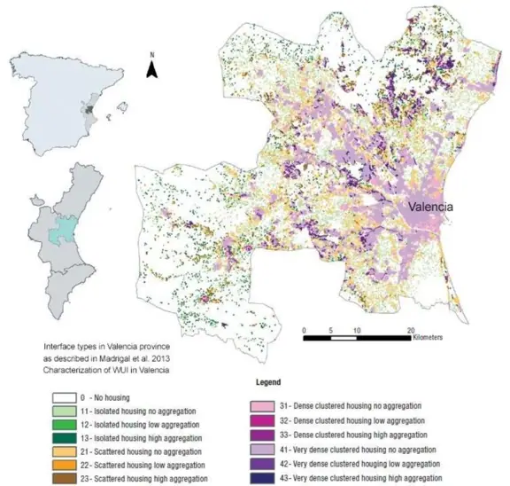
In the immediate surroundings of the city of Valencia, a growing agglomeration of smaller towns and housing developments is spreading out and intermingling with woodland and mixed forest and scrubland. This interface creates potential exposure of houses, people and property to the ignition, establishment and spread of wildfires with tremendous unwanted consequences, as has been repeatedly observed in real fires near the regional capital. Today these municipalities are overwhelmed by the situation, with a population that multiplies considerably in summer, precisely during the peak fire season, surrounded by increasingly unmanaged forests and a number of abandoned farmlands, and with precarious water availability. Tackling self-protection is a challenge for municipalities with limited capacity to develop infrastructure and access water for prevention and protection purposes. Although fairly insufficient fire-prevention regulations exist and are in force, only some of the communities located in these areas are aware of the dangers and of the need for self-protection.
1.3. The challenges of climate change
1.3.1. Climate change and fire risk
New factors are slowly but steadily aligning towards difficult scenarios of longer fire seasons, deeper and longer droughts, and more extreme weather with storms and strong winds, which challenge, and frequently overwhelm, firefighters and other protection bodies. It seems clear that we are facing new challenges and fire events of new dimensions, and this appears to be only the beginning. What we have witnessed in the United States and Canada in recent years seems to be happening progressively and steadily in Europe. Portugal, Spain, France, Croatia, Italy and Greece have suffered large numbers of fires, some of which became large wildfires that threatened towns and infrastructure, including several tourist facilities.
The European Partnership for Climate Adaptation has considered so-called wildland-urban interface fire to be one of the main impacts on the urban areas of the partnership’s members (EU Urban Agenda on Climate Adaptation, 8th Meeting of the Community of Users on Secure, Safe and Resilient Societies). According to the IPCC (Climate Change 2014: Impacts, Adaptation and Vulnerability, p. 19), increased wildfire risk has the highest level of confidence among future climate change scenarios. The European Environment Agency has stated that “In a warmer climate, more severe fire weather and, as a consequence, an expansion of the fire-prone area and longer fire seasons are projected across Europe. The impact of fire events is particularly strong in southern Europe” (European Environment Agency, Key Messages for Forest Fires Indicator Assessment)
1.3.2. Climate change and water resources
Various fire prevention or mitigation strategies rely on preventive or suppression irrigation, as we will describe in detail below. However, this approach faces a major obstacle related to the availability of water resources.
Water scarcity, meaning an imbalance between available water resources and existing demand, currently affects many European countries. At least 11% of Europe’s population and 17% of its territory are affected by water scarcity (European Commission. 2010. Agriculture in the EU, Statistical and economic information 2009, Directorate-General for Agriculture and Rural Development). The number of people living in river basins affected by water scarcity will increase, particularly in the Iberian Peninsula, Italy and relatively large parts of Central Europe (European Environment Agency, EEA 2010. The European Environment: state and outlook 2010, Copenhagen, Denmark: Adapting to climate change).
The CEPS working document “Future Impacts of Climate Change across Europe” (No. 324 / February 2010) states that the Mediterranean will face water scarcity problems more than any other region in Europe. Climate change may lead to an estimated decrease in water availability, which will be greatest in the Mediterranean and southern Europe (European Commission, 2009a; MICE, 2005). Water availability may fall by 20–30% under a +2°C scenario and by 40–50% under a +4°C scenario. Summer water flows may be reduced by up to 80%, and mean annual runoff will decrease in Central and Eastern Europe and in the Mediterranean by 0–23% up to the 2020s and by 6–36% up to the 2070s (IPCC, 2007b). This forecast is consistent with that of the European Environment Agency; in particular, for a high-emissions scenario (RCP8.5), the models (ensemble mean) project a statistically significant increase in annual precipitation in large parts of central and northern Europe (of up to about 30%) and a decrease in southern Europe (of up to 40%) from 1971–2000 to 2071–2100.
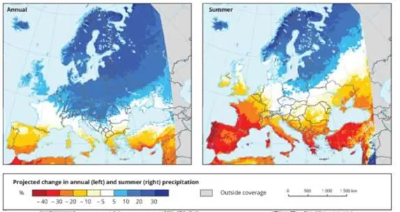
Figure 2. Projected change in annual and summer precipitation. Source: European Environment Agency, indicator assessment: mean precipitation.
We can therefore see that, logically, extremely dry seasons create the conditions for high fire risk (high temperature, low soil moisture) but, at the same time, reduce the availability of the water resources needed for fire protection in the wildland-urban interface. Models show that this situation will become increasingly frequent in southern Europe.
The Valencia region is located in the western Mediterranean basin (east coast of the Iberian Peninsula, Spain) and covers an area lying between 38° and 40° N (24,000 km²). Although water scarcity has historically been a constant in this region, recent drought episodes show a pattern that can be linked to the effects of climate change. The Mediterranean coast and the south-east of the country are the areas most affected by water scarcity and droughts, with the resulting socio-economic and environmental impacts.
According to the JRC’s European Drought Observatory (EDO), analysis of the long-term precipitation indicators (SPI-6 and SPI-9) available in the EDO highlights a long-term deficit in southern Spain, with potential impacts on reservoirs and rivers. The most affected areas are the Valencia and Murcia regions and the province of Almería. For example, in 2014 the JRC’s EDO reported that “Almost the entire territory of the provinces of Valencia, Castellón and Alicante experienced six consecutive months of extremely dry conditions from November 2013 to April 2014”.
As a consequence of these precipitation deficits, soil water content fell drastically. Soil moisture model data provide clear evidence of the areas suffering from the lack of rainfall, confirming the exceptional conditions that have prevailed since October 2013, with persistently negative values in the Valencia and Murcia regions and in Almería.
By 2030, a reduction in water resources of between 12% and 15% is expected in the Segura and Júcar basins, with serious consequences for soils and the deterioration of forest stands, slope instability, wildfires, and more crops and higher crop water demand. Within the Valencian Community, Riba-roja and Paterna lie within the areas with a negative water balance between availability and demand.
2. ZONING OF THE WILDLAND-URBAN INTERFACE
In recent years, and particularly within the framework of the European WUIWATCH project, three working scales have been considered for wildfire risk assessment and fire prevention planning in the wildland-urban interface: the macroscale or landscape scale; the mesoscale, corresponding to the dimensions of the settlements; and the microscale, referring to the detailed scale of the house and the plot surrounding the building.
2.1.1. The mesoscale and the transition zone
Of the three, the mesoscale has been identified as the key working scale for risk identification and for the design of defensible spaces, in which the relevant factors governing expected fire behaviour, such as fuel load and continuity and live fuel moisture content, among others, are modified to obtain controlled-risk environments and extended defensible areas. Three areas have been considered at the mesoscale: the outer mesoscale (also treated as the transition area), the perimeter and first ring of houses, and the inner mesoscale.
In line with the lessons learnt, several approaches to adapting the transition area include transforming and maintaining soil structure and moisture, selecting and treating plants, grazing, prescribing controlled burns and scheduling preventive irrigation. At the perimeter, a number of approaches and good practices are highlighted, including the design of low-flammability rings, the removal of flammable hedges and the design of automatic sprinkler systems. At the inner mesoscale, some guidance is provided, based on observations in real fires, to reduce fire activity, such as treating undeveloped plots, breaking hedge continuity and managing other non-vegetation materials that may add to the fire load.
3. THE UIA-GUARDIAN PROJECT
Against this background, the GUARDIAN project proposes a fire risk mitigation strategy that will be tested in the La Vallesa area, at the interface between the urban areas of Riba-roja and Paterna and the Parc Natural del Túria. Thanks to the support of the European Union’s Urban Innovative Actions programme, a solution will be implemented that links the results of previous European projects in the fields of fire prevention and advanced water reuse methods.
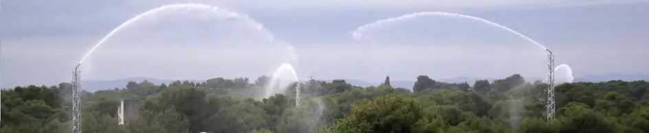
The project proposes a combined strategy based on the use of recycled water for fire prevention and protection, providing automatically scheduled preventive, suppression and extinction irrigation/soaking patterns: GUARDIAN will build the hydraulic infrastructure to supply recycled water to the La Vallesa wildland-urban interface, together with the elements (irrigation towers and sprinklers) that make up the defensive barrier. The installation, located along the fire line, will integrate the sprinklers with high-pressure hydrant cannons covering the perimeter, based on the WUI-PROTECT system.
In addition, soil and vegetation works will be carried out (reducing tree density, particularly of suppressed or weakened trees, ladder fuels, pruning, shrub spacing, reducing tree and vegetation debris, etc.)
The use of recycled water to provide the water resources needed for fire protection infrastructure, as proposed by GUARDIAN, has no known precedent and greatly enhances its applicability. Reused water has been applied to some extent in conventional firefighting and is in fact regulated by Spanish law (RD 1620/2007). The project will also contribute to the sustainability of the La Vallesa wetland through its restoration and the replacement of low-quality inflows.
3.1. Preliminary studies
A set of preliminary studies and a field survey will lay the foundations for the risk analysis and the subsequent design of the solution. First, a detailed characterisation of vegetation structure will be carried out through field inspection and analysis of LIDAR data. This will lead to the characterisation and mapping of forest fuel load (kg/m²), fuel continuity and vertical structure.
Historical records from nearby weather stations will be analysed and correlated with the corresponding fire danger indices (such as the Canadian FWI). The expected evolution of the climate will be included, particularly in describing periods of drought, extreme weather (winds) and episodes of high temperature and low humidity. Finally, a land survey will be carried out to obtain a map of the existing vulnerable elements (houses, critical infrastructure, businesses, services, etc.)
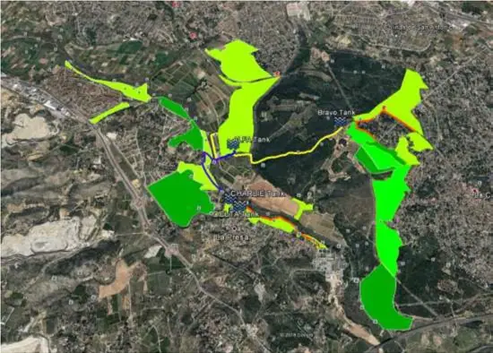
Figure 3. Outline of the solution. In light/dark green, areas proposed for the transformation of vegetation structure. The hydraulic infrastructure is shown in blue and yellow. Source: authors’ own elaboration
In the next step, based on historical records, weather patterns and the expected evolution of climate scenarios, the potential development of wildfires and the intensity and extent of their effects on vulnerable elements will be identified. To achieve this, expert assessment and simulation models will be used to estimate energy release, fireline intensity, radiative energy emission, rate of spread and potential spread paths (propagation). The output will be combined with vulnerability and exposure (distances) to obtain, by means of risk functions, the probability of unwanted consequences, which will eventually be reflected in a risk map.
3.2. Risk mitigation
Fire risk mitigation focuses mainly, but not exclusively, on treatments of vegetation structure. The design of the vegetation treatments serves a dual purpose: to limit and control the continuity of the fuel load and, on the other hand, to protect soil structure and water availability. This means, first of all, sizing the extent and intensity of the treatments on the land surrounding the urban settlement (transition zone) by means of a specific algorithm based on the expected radiant heat release. The proposed treatments will seek to protect the soil from intense evapotranspiration by ensuring sufficient canopy cover while, at the same time, avoiding fuel continuity. In addition, soil protection will include soil treatments (i.e. organic amendment) and cover with protective vegetation. The specific treatments at the settlement perimeter will be sized and designed to provide a controlled fire-intensity environment (below 3000 kW/m). This will include fuel reduction, but also mobility for firefighting operations. Finally, the design of the treatments will be extended to inner plots, gardens and common green areas.
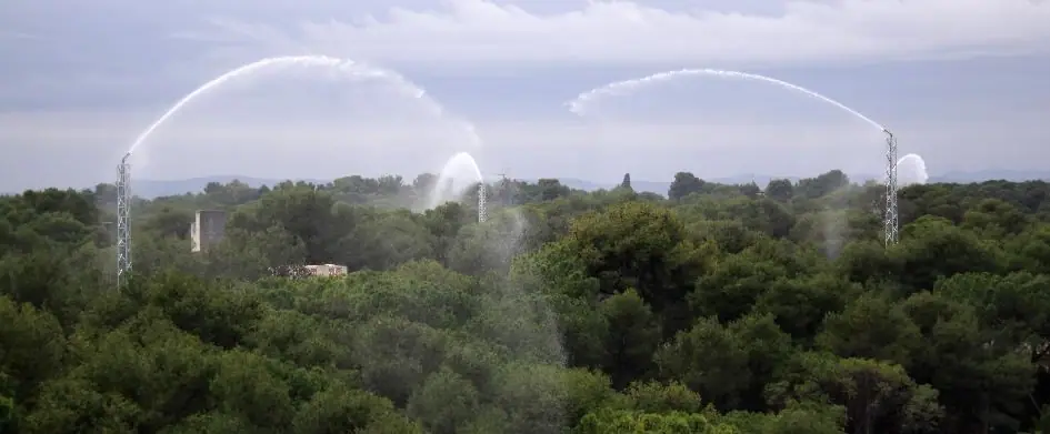
Figure 4. WUIPROTECT® Wildfire Defence System installed on the perimeter of a wildland-urban interface. Source: Medi XXI GSA
3.3. System management
Automated management of the system will be based on the implementation of customised indices for the additional monitoring of live vegetation moisture content, fine dead fuel moisture content, and fire behaviour components and energy release indicators (probability of ignition, fireline intensity, rate of spread, radiant heat emission, etc.). All of these will be fed with monitoring and forecast data as detailed, particularly the state of the atmosphere (temperature, relative humidity, precipitation), the weather forecast and the condition of the live vegetation. The resulting indices point to particular water control and distribution vectors, such as preventive irrigation (according to the live vegetation index), suppression irrigation (according to the fine dead fuel moisture index) and extinction irrigation (according to the fire behaviour indices).
Monitoring is carried out locally and complements the general readings and forecasts of the overall atmosphere (as provided by official sources such as the State Meteorological Agency, AEMeT, or regional weather services). Monitoring includes readings from soil sensors (soil temperature and moisture content, at depths of 0, 10 and 20 cm), vegetation condition (as derived from colorimetric analysis of ground-based multispectral cameras and satellite imagery) and medium-sized dead fuel (10HR) using specific sensors. In addition, information from local automatic weather stations (AWS) will also be collected and transmitted (data logger via GSM) to the control centre (CCS) to be processed and incorporated into the calculation of the indices.
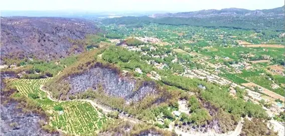
Figure 5. Defensive perimeter. The foreground shows intact vegetation (green land) within the range of action of the WUIPROTECT® cannons. Source: Medi XXI GSA – WUIWatch project.
The core of the innovative nature of the proposed solution lies in the development and integration of a command and control system (CCS) and a set of algorithms that first collects monitoring and forecast data, calculates current and future indices, applies decision inference rules and, finally, delivers a schedule for the different irrigation modes mentioned above. In particular, the GUARDIAN CCS will calculate, based on the forecast Drought Code (DC), the amount and spatial distribution of irrigation needed to offset the soil moisture deficit and correct that DC, and will deliver it automatically. In addition, in the event of high or very high fire danger, or when facing an approaching fire, the GUARDIAN CCS will estimate, based on the expected evolution of fine fuel moisture, the amount, timing and spatial distribution of suppression irrigation needed to reduce the likelihood of spot fires and fire development, and will deliver it automatically. Finally, the GUARDIAN CCS will keep a record of the water available for suppression and, according to the calculation of expected fire behaviour and energy release, will automatically suggest the production of an additional volume of treated water for firefighting operations, to be stored accordingly.
3.4. Organic micropollutants as a barrier to reuse
Over recent decades, developments in analytical techniques (mainly liquid chromatography (LC) coupled with mass spectrometry (MS)) have made it possible to detect organic compounds of anthropogenic origin whose presence was previously unknown owing to their relatively low concentrations (µg/L – ng/L) (Omil et al. 2010). These compounds are generally known as organic micropollutants (OMPs), contaminants of emerging concern (CECs) or trace organic contaminants (TrOCs), and their effects on the environment and human health are uncertain. This is precisely the case of the Camp de Túria II WWTP, whose treated effluent is intended to be used as a resource for the fire prevention and mitigation system described above. Specifically, the most relevant OMP at this WWTP is chlorpyrifos, an organophosphate pesticide widely used in homes and in agriculture.
Water reuse represents a sustainable alternative to the use of conventional water resources or seawater desalination, and in recent decades it has been widely considered in circular economy approaches. However, the presence of organic micropollutants in WWTP and WRP (water reclamation plant) effluents has raised global concern about the impact of these OMPs on the different uses.
The presence of OMPs in direct and indirect reuse schemes poses an uncertain risk to human health when people may come into contact with, or directly or indirectly consume, this water. In agriculture, irrigation could also pose a risk when these compounds can be taken up by soil and crops. On the other hand, the use of reclaimed water for environmental purposes (such as fire control systems and maintaining river flows) may pose a risk to soil, the aquatic environment, plants and animals.
3.5. Previous experience: results of LIFE Aware
From 2013 to 2016, CETAQUA, the Water Technology Centre, coordinated the LIFE AWARE project. The total budget was €2.6 M, co-funded by the LIFE+ Programme, and Aigües de Barcelona (Spain) and LNEC (Portugal) took part as partners.
The AWARE project assessed an innovative hybrid water reclamation scheme for OMP removal, which was compared with state-of-the-art systems. To carry out this comparison, two prototypes were operated for 18 months at the El Baix Llobregat Water Reclamation Plant (WRP). The prototypes consisted of the following:
- Prototype 1: membrane bioreactor with spent powdered activated carbon (PAC) dosing
- Prototype 2: capillary nanofiltration with virgin powdered activated carbon (PAC) dosing
Figure 2 shows the layout of the prototypes operated. As can be seen, the PAC dosed into the contact tank of prototype 2 was filtered through a capillary NF, and the reject stream, containing concentrated PAC, was recirculated to the biological tanks of prototype 1.
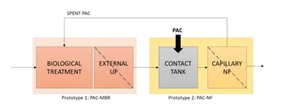
Figure 6. Layout of the prototypes operated in the LIFE aWARE project
The basic WRP at El Baix Llobregat, on the other hand, consists of CAS (conventional activated sludge) followed by coagulation-flocculation, lamellar settling, microfiltration and disinfection (UV). The main reclaimed water uses were urban (irrigation, street cleaning), agricultural and environmental.
Removal of recalcitrant OMPs (such as carbamazepine and diuron), removal of biodegradable OMPs (such as ibuprofen, acetaminophen, sulfamethoxazole and codeine), cost difference relative to the basic WRP and environmental footprint were assessed for different schemes in Table 1.
Table 1 Removal efficiencies, cost difference and environmental footprint for different treatment schemes. Source: LIFE aWARE project
| Scheme | Recalcitrant OMP removal (%) | Biodegradable OMP removal (%) | Cost difference vs. basic WRP | Footprint difference vs. basic WRP |
|---|---|---|---|---|
| Basic WRP | 12 | 60 | – | – |
| MBR | 15 | 70 | +30% | -50% |
| Basic WRP upgraded with O3 | 80 | 95 | +19% | +15% |
| PAC-MBR (25 mg/L virgin PAC) | 60 | 75 | +60% | -50% |
As can be seen, low removals of recalcitrant OMPs are obtained in the basic WRP (12%). Membrane bioreactors, owing to their longer SRT and HRT, improve recalcitrant OMP removal to 15%, with an associated cost increase of 30%. By upgrading the basic WRP with ozone, it is possible to achieve 80% removal of recalcitrant OMPs at +19% cost and +15% footprint, whereas a hybrid system (PAC-MBR) makes it possible to achieve 60% removal of recalcitrant OMPs at +60% cost and with a 50% reduction in footprint.
3.6. Application to the GUARDIAN project
Several recalcitrant OMPs need to be removed at the Camp de Túria II WWTP (Riba-roja, Spain), especially organophosphate pesticides such as chlorpyrifos. Considering the potential reuse of this water in fire control systems and the sorption properties of this target pesticide, the use of PAC-MBR offers major advantages in terms of reclaimed water quality, OMP removal efficiency and associated footprint. However, the associated cost and environmental footprint of these systems are high. In order to maximise OMP removal and reduce the PAC dose (which increases cost and carbon footprint), a hybrid PAC-O3-MBR system is proposed.
The advantages expected from the PAC-O3-MBR system compared with state-of-the-art systems and with PAC-MBR systems are summarised below:
- Higher overall removals for all OMPs (> 85%) owing to the combined effect of biotransformation-oxidation and adsorption, and removal through adsorption of the metabolites generated by oxidation. – Lower PAC dose owing to slower saturation of the adsorbent
- Lower sludge generation and greater disinfection.
- Improved sludge filterability makes it possible to apply higher filtration fluxes in the UF and thus reduce the associated investment and operating costs.
A prototype with a total reclaimed water production of 10 m3/h will be designed and installed at the Camp de Túria II WWTP to reclaim water that is safe (from an environmental and human-health standpoint) for fire control systems and for environmental purposes, including restoring the quality of the La Vallesa wetland. As can be seen in Figure 3, the proposal is a biological treatment (anaerobic, anoxic and aerobic) with PAC dosing and O3 injection, coupled with an ultrafiltration membrane.
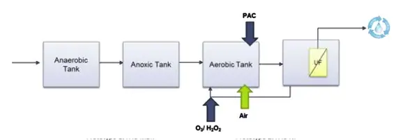
Figure 7. Layout of the PAC-O3–MBR prototype. Source: LIFE Aware project
Different membrane options will be considered during the design tasks: – Option 1: external UF after the aerobic tank (sludge filtration)
- Option 2: UF submerged in the aerobic tank (sludge filtration)
- Option 3: UF submerged in the secondary clarifier (filtration of the clarified secondary effluent), which would mean that instead of an MBR the system would be CAS + PAC + O3 followed by a UF membrane.
4. ANALYSIS OF PROJECT RESULTS
The circular economy approach has proven to be a suitable option for efficient, equitable and sustainable water management. In addition, optimisation techniques are a useful tool to support water allocation decision-making. An optimisation model represents a novel approach that considers the efficiency of water distribution and the physical connections between water supply and demand points.
In this project, we propose to develop and apply a water optimisation model that considers the availability of reclaimed water and its social and environmental benefits. Including future climate change, population growth and risk analysis will allow us to suggest a balanced development path for the water resources available in a specific territorial area.
Selecting best practices/strategies to improve the effectiveness of water management requires considering multiple objectives and criteria (e.g. economic, environmental, technical and social) and the complex interactions between them at the same time. Furthermore, a reliable analysis of water management requires identifying the strengths and weaknesses of the different operating strategies and including uncertainty/risk in the assessment procedure in order to analyse how it affects decision-making processes. This complexity makes it necessary to develop a rigorous and systematic multi-criteria decision analysis that supports policy-makers in appropriately assessing and comparing alternatives within a cost of no action versus cost of action (CNA-CA) approach.
In the context of water policy analysis, we also propose an impact assessment of these actions in terms of economic efficiency and the sustainability of water use in urban areas.
The socio-economic assessment of the proposed measures will be carried out using mathematical programming and econometric models that seek optimal solutions. Estimating cost functions for specific activities, processes or technologies will make it possible to identify the behaviour of cost elements as well as cost drivers. The efficiency of the different proposed measures will be studied using data envelopment analysis (DEA) models.
To analyse the feasibility of different actions, the social and environmental benefits of the proposed actions will be quantified using a new methodology based on the calculation of shadow prices.
Costs and benefits will be analysed from a dynamic perspective, considering various scenarios under uncertainty.
Several methodologies (Monte Carlo simulation, statistical tolerances and fuzzy modelling) will also be used to quantify the reduction in wildfire risk achieved through the implementation of the proposed project.
5. CONCLUSIONS
Climate change is expected to increase the frequency and severity of wildfires in the coming decades while simultaneously reducing the availability of the water resources that are a key tool in defending against them.
The UIA-GUARDIAN project offers a unique opportunity to test, over the coming years, combined and effective fire risk mitigation strategies in the most vulnerable areas (the wildland-urban interface) using alternative water resources. It also makes it possible to capitalise on the results of previous projects in very different fields, and it simultaneously addresses several aspects of climate change.
GUARDIAN demonstrates the untapped potential and importance of water reuse in a context of growing water scarcity. Its contribution to the study of the economic feasibility of advanced reuse treatments in a real application setting is also fundamental.
The GUARDIAN project is led by Riba-roja Town Council, with the participation of Hidraqua, Medi XXI, Universitat Politècnica de València (IIAMA), the Water Economics Group of the University of Valencia, Paterna Town Council and the Parc Natural del Túria (Generalitat Valenciana).
REFERENCES
AEMA (2012) Los impactos del cambio climático en Europa: evaluación basada en indicadores. Informe conjunto de la AEMA, CCI y OMS. Oficina de Publicaciones de la CE y Ministerio de Medio Ambiente, Medio Rural y Marino, Madrid, 240 p.
BEHRENS, A. et al. (2010) Future Impacts of Climate Change across Europe. CEPS Working Document No. 324. http://www.ceps.eu
CALKIN, D. et al. (2014) How risk management can prevent future wildfire disasters in the wildland-urban interface. Proceedings of the National Academy of Sciences of the USA.
DICUS, C. (2016) Changing WUI fire risk in dissimilar communities of Southern California, USA. Proceedings of the International Conference on Forest Fires and WUI Fires. Aix-en-Provence, France. California Polytechnic State University.
FUENTES, R. et al. (2017): Productivity of wastewater treatment plants in the Valencia Region of Spain, Utilities Policy, 46, pp 58-70
HERNÁNDEZ-SANCHO, F et al. (2015): Economic Valuation of Wastewater – The cost of action and the cost of no action. United Nations Environment Programme. ISBN: 97892-807-3474-4
HERNÁNDEZ-SANCHO ET AL. (2015): Pricing for Reclaimed Water in Valencia, Spain: Externalities and Cost Recovery, in Dinar, A., Pochat, V., Albiac, J. (Eds.): Water Pricing Experiences and Innovations, Springer International Publishing, pp. 431-443, ISBN: 2211-0631
MADRIGAL OLMO et al. (2013) Characterization of wildland-urban interfaces for fire prevention in the province of Valencia (Spain) Forest Systems Vol 22, No 2. Instituto Nacional de Investigación y Tecnología Agraria y Alimentaria
MODUGNO, S. et al. (2016) Mapping regional patterns of large forest fires in WildlandUrban Interface areas in Europe. Elsevier.
OMIL, F. et al. (2013) Removal of Pharmaceuticals by Membrane Bioreactor (MBR) Technology Comprehensive Analytical Chemistry 287-317, Vol.62, Chapter 9. Elsevier
PRATS, D. and MELGAREJO, J. (2006) Desalación y reutilización de aguas. Situación en la provincia de Alicante, pp 139-144. COEPA- Instituto Universitario del Agua y Ciencias Ambientales.
VARIOUS AUTHORS (2016) LIFE aWARE: Innovative Hybrid MBR Systems to promote Water Reuse – Lyman’s Report. http://www.life-aware.eu
A replicable solution
GUARDIAN shows that reclaimed water can protect the wildland-urban interface. Let us know if you would like to apply it in your municipality.